
Senior Matt Lebowitz is reporting on Hamilton's spring break trip to the Mt. Everest base camp. Members of the nine-person group are enrolled in Professor Maurice Isserman's History of the Himalayan Mountaineering course. This is the final entry.
March 25 -Hello from New York!
We just arrived safely back home in the States after about 24 full hours of traveling, and we have yet another five or so hours of driving up to Hamilton. Everyone is tired and happy, and I’m confident in my ability to speak for everyone when I say that we absolutely can’t wait to get back to campus, specifically to our beds.
Yesterday morning, we went to the lovely home of Hamilton’s own Ishan Mainali '21 in Kathmandu, whose family graciously invited us to come for tea. Lively conversation with his mother, father, and sister helped us get the day off to a wonderful start, and we were grateful for their company and interest in the trip.
Afterwards, some of us did some extra sightseeing at Patan Durbar Square, a section of Kathmandu lined with medieval palaces alongside Hindu and Buddhist temples. Our fast-talking, excitable tour guide ushered us this way and that. “Three major religions in Nepal,” he proclaimed. “Hinduism, Buddhism, and Tourism!”
Our jaws dropped at the intricacy of the artwork and sculptures that adorned the walls and doorways of the temples and palaces. Centuries-old carvings here, golden statues there, tourists everywhere. Hinduism and Buddhism piled on top of one another, history layered in a way I’d never experienced before. Our guide capped the tour with a visit to what I assume was his buddy’s shop, and what followed was a sales pitch like no other.
Our guide’s friend sold singing bowls of all types at his shop. These bowls, which resonate when circled with a wooden mallet, are popular souvenir items, but here we learned that there is more to the art than meets the eye. For starters, there were actually two different types of bowl in the shop: singing bowls, made in a factory from a combination of copper and tin; and healing bowls, pounded in the shop by hand from a combination of seven metals also including gold and silver.
Through pitched vibrations specific to an individual’s chakras, these healing bowls are used to relieve physical ailments and aid in meditation. To demonstrate the bowl’s effects, the shop owner poured in some water. When the bowl resonated with the mallet, the water leapt up and splashed us! Since so much of the body is made up of water, these vibrations are thought to have therapeutic effects.
The owner asked for a volunteer, and I immediately raised my hand. He placed a large healing bowl upside down on my head and struck it lightly with the mallet. The result was a somewhat indescribable, though pleasant, feeling of vibration that went down from my head to my torso. Everybody eventually tried this and even reported still feeling the effects several minutes later. Full disclosure, I did indeed buy a healing bowl, medium size and pitched to a D note. It’s awesome.
After a late lunch at a local café, we took naps and enjoyed reading in the warm, breezy weather before heading to the airport around 6 p.m. Nepal time last night. We’ve been traveling ever since, but at least we’re homeward bound.
I could write that this trip was an incredible (and at times incredibly trying) wilderness adventure, and that would be true. I could write that it was a wildly varied walk through Nepalese life both rural and urban, and that would also be true. For some, it was an exercise in hardiness and endurance, and for others a vivid exploration of entirely new landscapes and ways of life. For many it was both.
A trip like this one often defies categorization, and these blogs have helped me to record experiences that would otherwise be jumbled memories and lessons without a common tether. The more I write, the more I realize that these experiences are not bound so much by themes or topics, but by common states of mind. Flexibility and open-mindedness are the keys; it’s all there for you, sometimes if you look for it but more often if you don’t look for anything in particular.
So, even though I failed in my personal quest to find a yeti, I saw my favorite mountain in person, learned a bit of a new language, and made some new friends (both humans and yaks) along the way, and that’s all pretty damn cool.
Thanks for reading!
March 22 - Namaste from Kathmandu!
All 10 of us have arrived back in Kathmandu! The weather cleared this morning, and we flew out of Lukla at around 6:30 am. Same tiny, rickety plane, same terrifying airstrip. Since the runway dips down off the cliff, taking off feels like riding a rollercoaster!
Midway through the flight, the attendant stood and got our attention. She said something that couldn't be heard over the din of the engines, and all of us smiled and nodded.
A few minutes later, we landed safely - but not in Kathmandu. Fog and smog in the city had forced our flight to divert, and suddenly we found ourselves sitting on the tarmac of a tiny airstrip in some village way outside of Kathmandu waiting for conditions to clear. If they didn't, we'd take a five-hour bus ride.
Some people played cards, some read, and some slept on their backs, heads propped against backpacks, lounging in the morning cool. The pilots leaned against the plane. I sat on a rock and played my travel guitar, got bored and walked a few laps around the 1940s-era airport, sat down, stood up, sat down again. After around an hour and a half, the pilots got the all-clear, and everyone piled back in. Thirty minutes later we landed in Kathmandu. All before 9 a.m.
The rest of today we spent resting. I finished a book and started another, ate some chocolate, and enjoyed the warm weather. Our group finally got its "spring break" day. All of us went out to dinner and promptly passed out upon returning to the hotel.
March 21 - Namaste from Lukla!
We finished the last segment of our trek today! A slow start to the morning, a few hundred meters of gradual elevation gain, a lazy lunch, and a slow roll into Lukla town capped the hiking portion of our Himalayan adventure.
We settled into our guest house, located right next to the airport we flew into, and set off to explore the town. There's a lot of tourism money here, and this place almost resembles a mini Namche Bazaar.
Today was very cloudy, and the weather grounded all planes flying to and from Lukla. Our flight back to Kathmandu is scheduled for 6:30 tomorrow morning, and we are all hoping that the weather clears up by then. If not, we stay and explore Lukla!
If we fly out tomorrow, we'll have most of that day, all of Friday, and most of Saturday to spend in Kathmandu. The group is currently in the process of figuring out how to use this time, but it promises to be exciting!
March 20 - Namaste from Phakding (again)!
I haven't had internet access for days, so there’s lots to cover in this update! On March 15, we climbed out of Namche Bazaar (11,312ft) and started on our way to Tengboche Monastery, 4.6 miles away and 2,336 feet above. Just out of Namche we found ourselves on an absolutely wonderful ridge trail that skirts the 21,145ft Thamserku and 21,392ft Kangtega. Suddenly, the trail turned a corner and revealed the most stunning vista yet, with the centerpiece we'd all been waiting for: Everest, the highest mountain in the world, with her trademark cloud plume shooting east from the 29,028ft peak. All at once, the mountains of our studies and dreams stood proudly in front of us. The beautiful, 22,493ft Ama Dablam (my personal favorite mountain) gleamed in the sunlight just northeast of Thamserku. Ama Dablam, or “Mother and Daughter,” is so-named for the secondary peak which rises 20,242 feet just west of the main peak. Just to the east of Everest, Lhotse (27,890ft, the fourth-highest mountain in the world) shoots up from the massif like a fang. Directly to the southwest of Everest lies Nuptse (25,790ft), and Toboche Peak (20,889ft) rounded out our vista. In just a few moments, Everest, Lhotse, and Nuptse were shrouded in cloud.

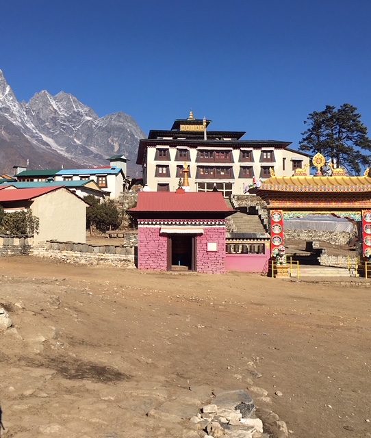
We descended a bit through a forest, and lunched beside a rippling stream. It grew cloudy and cold, and as we began to ascend the other side of the ravine it started to snow. The weather and increasing altitude made this final push difficult, but everybody made it to Tengboche without too much trouble. We even saw a few mountain goats clinging to the side of the mountain as they grazed. Upon arriving at the top of the mountain, we immediately had a brief tour of the monastery, which is around 700-800 years old, and most of us were too tired to stay awake past dinner.
March 16 dawned clear on Tengboche, and Andrew woke us up at 6 a.m. to show us a crystal clear view of Everest. Through his powerful binoculars we could see the Hillary Step, an imposing 40-foot cliff that poses the last obstacle before the summit. New Zealander Sir Edmund Hillary first navigated a way up this cliff in 1953, shimmying himself up a crack in the wall. He and his climbing partner, Sherpa Tenzing Norgay, were the first to summit the highest mountain in the world just a few steps later. On the other side of the summit we could see the First, Second, and Third Steps, upon which mountaineers George Mallory and Andrew Irvine had struggled and perished nearly a hundred years ago in 1924.
Having taken in the view, we departed for the village of Dingboche (14,566ft), 5.3 miles away and 2,181 feet above. As we climbed gently above the treeline, the landscape became sub-alpine and incredibly barren. We crossed several glacial rivers and ascended into desolate highlands. After six hours, we trudged through the Himalayan dust and into the village of Dingboche.
Though we were tired, many of us opted to explore the town a little bit. We stopped in at a local bakery, where I had the driest apple pie of my life. Several of us bought junk food snacks before heading to bed. That night, one of our team got very sick with food poisoning — their sketchy, expired, pizza-flavored Pringles chips had had a broken seal. A small mistake, a funny story in hindsight, but one that would end this person’s ascent.
The next day, March 17, our sick friend went with a guide down to Pangboche (~12,500ft) while the remaining eight of us continued on towards Lobuche (~16,000ft). It is at this point that I must stress the abnormal scheduling of our trek. Most trekkers on this route take up to fourteen days to accomplish what we had scheduled for only ten. We had been ascending thousands of feet per day without rest or acclimatization, and it would all catch up to us in Lobuche.
We took a high trail from Dingboche through some frozen peaty marshland, and despite the altitude it was fairly easy going. Good weather, slight upwards gradient, beautiful scenery. We arrived at our lunch location at the snout of a glacier a full two hours early. After a short rest, we opted to go ahead and hike the several-hundred-meter-high hill of crumbling rock and ice. We hoped to knock the day's hiking out of the way early and eat a late lunch at our destination.
We began to strongly feel the effects of our deferred meal in addition to the altitude. I felt lightheaded and totally spent as we walked into the teahouse in Lobuche. Within minutes of sitting down, several people developed symptoms of Acute Mountain Sickness (AMS). Headaches sharpened, nausea worsened, and you can Google the rest of it.
At the end of the night, a plan was made: the following day, the four sick members of our group would descend with a guide while the remaining four healthy members would wake up at 4:30 a.m. for a 9-10 hour trek with Andrew to Everest Base Camp and back to Lobuche. Our time crunch meant that the ascending group would be unable to sleep any higher, and they would have to cover over twice the distance of our average day's hike.
In the course of the night another person fell ill, and the decision was made pretty unanimously that we would all descend the next day.
So, on March 18, our ragtag group meandered down the mountain, past the glaciers and the highlands, and stopped to rest for the night in Panboche village, about halfway between Tengboche monastery and Dingboche town. We started the day’s hike with much difficulty; those suffering from AMS had barely eaten anything in the last 24 hours and were completely drained of energy before even starting the day. With each step downwards, however, we could feel the air thickening, and before long the nausea and headaches had gone away. Our appetites returned, we reunited with our poor food-poisoned friend, and we ended the day much happier than we’d begun it.
On March 19, we slept an extra half hour before waking up to leave for Namche Bazaar. We had a long day of hills ahead of us, even though we would ultimately end up at a lower elevation. We left the treeless highlands for the shade of a rhododendron forest as we climbed towards Tengboche. We found the monastery in much fairer weather than we had last time, and we could see Everest perfectly clearly. We had tea and took photos before continuing on.
The brutal uphill switchbacks we had used to reach Tengboche the first time proved just as taxing on the descent. What had strained our quadriceps on the way up and pummeled our knees on the way down. After an hour of careful descent, we reached the bottom of the ravine and had lunch beside that same rippling stream.
After lunch we tackled the thousand-foot climb back out of the valley. Not much to say about this, other than that we took it slow and it was tough on our friends still recovering from sicknesses. We were rewarded with some of our final views of Everest, Lhotse, Nuptse, and Ama Dablam as we rolled along the ridge trail which had afforded us our very first views of those great peaks. After a nearly eight-hour day, we descended exhaustedly into Namche Bazaar. We spent the night resting our sore bodies, playing cards, and telling stories.
Today, March 20, we descended about 2,600 feet straight down into the valley below, and the biggest “up” of the trek became the biggest “down.” We exited Sagarmatha National Park an hour later and had lunch just outside the Park's borders. The veggies we had were grown right outside the teahouse where we ate.
Tonight we are staying at the same guest house as we did on the 13th. From here it is an easy hike to Lukla, where we will spend tomorrow night before returning to Kathmandu on the morning of the 22nd. As always, I'm looking forward to sending more updates as we continue our adventures in Nepal!
March 14 - Namaste from Namche Bazaar!
Today, we woke up early and set off from Phakding, en route to Namche Bazaar, the Sherpa Capital of Nepal.
After three hours of trekking alongside the river, crossing several times using suspension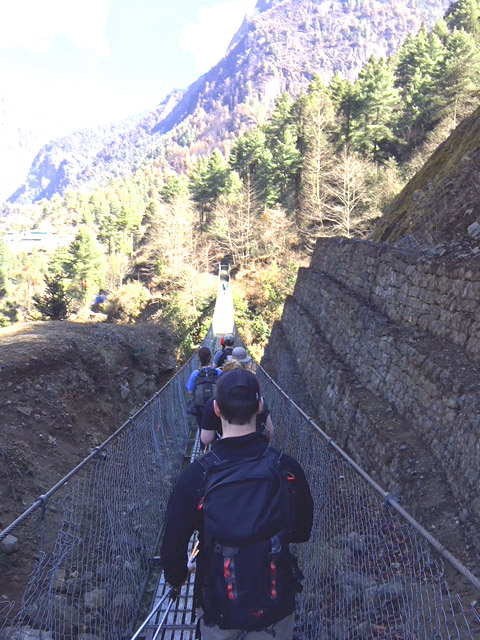 bridges that sway over the swirling blue rapids below, we stopped for lunch before entering Sagarmatha National Park. Sagarmatha is the traditional Nepalese name for Mount Everest, meaning “Head of the Sky.”
The next three and a half hours to Namche Bazaar were entirely uphill, and we climbed 800 meters in total today. Around 3:30 p.m. we finally arrived, tired and triumphant, in Namche Bazaar. We took tea in the guest house and explored for two hours before dinner.
The center of town is very tourist-oriented, with the most Western-looking and expensive gear shops on the trail. There are also many local trinket shops, and I bought a few Buddhist prayer flags and a good luck charm.
At this point, at around 11,000 feet, most of us are feeling the effects of altitude. I feel shorter of breath after exertion, and lightheaded at rest, but everyone is in very good spirits. It’s hard not to be excited about the new villages around each bend and the new towering peaks that come into view every day!
 March 13 - Exploring Kathmandu; Beginning Everest Base Camp Climb
Yesterday, we spent our first full day in Nepal playing tourist and visiting three cultural sites. First, we drove to the imposing Monkey Temple, perched high above Kathmandu Valley on a steep hill. Stupas are dome-shaped religious monuments adorned with Buddhist symbolism. The hilltop is indeed overrun by little Capuchin-like monkeys eager to steal snacks and jewelry from unsuspecting tourists. As ornate as the temple was, the highlight of this first stop was a brief presentation on Buddhist art. The most intricate of the translucent square mandala paintings take grand masters more than two months to complete, despite being approximately 10 inches by 10 inches!
Next, we visited Boudha Stupa, the second largest stupa in the world, located in the heart of Kathmandu. Groups of monks shuffled along its sides, spinning prayer wheels and bowing their heads. We had lunch at a local restaurant before continuing to a site along the Bagmati River, where we witnessed several cremations. In the Hindu tradition, on the day of death, a body is ceremonially bathed with the holy waters of the river before being burned upon a decorated pyre. The ashes are then cast into the river, which flows south into the Ganges.
The cremation sites are incredibly public, and as the family members grieved many in our group felt strange watching the rituals as if we were intruding on something that should be very private. Yet, dozens of Nepalese lounged around casually and watched, and the cremations are very clearly a normal part of life in this part of Kathmandu. The openness of the cremations represents a dramatic departure from most American funeral traditions, and I think that this final visit of the day stuck with us the most. We returned to the hotel to pack and rest for the remainder of the day.
We awoke at 4:30 this morning to catch a 6 a.m. flight out of Kathmandu. The propeller plane was just barely large enough to fit our group; everybody had a window seat. As we rose above the clouds, we caught our first glimpses of the Himalaya. I can only speak for myself, and words nearly fail to describe the scale of these behemoths. All other mountains that I’ve seen pale in comparison. I’ve been on top of a 14,000 ft. mountain in Colorado, and the highest Himalayan peaks are over twice that height. Even viewed from a plane at a distance, their enormous faces take up massive swaths of sky as their icy fangs rise to nearly the cruising altitude of a commercial passenger jet. “Awe” is too small a word.
About 40 minutes later we were within sight of our destination, Lukla’s Tenzing-Hillary Airport, often named the world’s most dangerous airport. The minuscule runway slopes uphill and ends abruptly against a cliff. Our plane literally made its approach from below, and as we bumpily touched down I thought I would vibrate right out of my seat. We landed quite safely, to everyone’s relief (surprise?) and fairly immediately began hiking.
 We switched constantly from looking down at the rocky trail and up, up, up at the peaks above. We passed through several villages before stopping for lunch at 10:30 a.m. We ate and rested on an open terrace until just before noon, when we started again. We continued for another hour and a half before stopping in the lovely village of Phakding, where I now sit sipping tea and writing. An easy day.
Tomorrow we tackle the toughest portion of the trek, a six- to seven-hour hike capped by an 800-meter climb up to the “Sherpa Capital” of Namche Bazaar. We must remind ourselves to go at a very slow pace, for many of us are already feeling subtle effects of the altitude. I can't wait to explore Namche Bazaar and report back what we find!
Follow our journey through Nepal on this interactive map.
March 12 - Hamilton Hikers Safe in Kathmandu via Abu Dhabi
Nine hardy Hamiltonians and one brave Brit rocketed towards Abu Dhabi on an Airbus A380, the largest passenger plane in the world, en route to Kathmandu, Nepal. As we settle into our seats, we shun thoughts of sunny beaches and lazy days playing video games in search of a greater spring break adventure: for the next two weeks, we’ll be trekking the famous route from Lukla Airport (look it up, it’s terrifying) to Mount Everest Base Camp, experiencing life in the heart of the Himalaya.
I’m Matt Lebowitz, a senior literature major currently enrolled in Professor Maurice Isserman’s History of Himalayan Mountaineering course. I’ll be corresponding as often as possible over the course of this trip, sending updates and photos. To further check on our progress toward Everest Base Camp, check out the interactive map of students’ spring break activities, where our location will be regularly updated via GPS.
I decided to take Professor Isserman’s course to indulge my childhood fascination with mountaineering, and the class has revived my curiosity about the subject tenfold. This trip not only offers a once-in-a-lifetime opportunity to travel to Nepal, a region of storied peaks and incredibly varied landscapes, but also the chance to engage with local culture in the villages we’ll pass through.
Andrew Jillings, fearless figurehead of Hamilton’s outdoor education programming, has been leading us onward since our departure from the Hill at 5:30 a.m. this morning. While I can’t say we’re excited at the prospect of spending the next 18 hours traveling (although the in-flight movie selection is quite impressive), our rugged destination looms large in our collective imagination. Personally, I’m looking forward to seeing mountains about which I’ve been reading all semester, bonding with the group under Andrew’s capable guidance, and learning a few words of Nepali along the way!
Photos and more updates are certainly to come, and I encourage you to check in with us regularly!
Matt
